
Orthos, Meshes, & 3D Models
Orthomosaics
Construction teams often rely on fragmented, outdated, or distorted site imagery. Ground photos lack context. Hand measurements vary. And without a consistent, accurate view of the entire site, miscommunication becomes inevitable — leading to delays, rework, and costly disputes.
Droneology solves this with high‑resolution aerial orthomosaics — distortion‑free, true‑to‑scale maps that give your team a single, reliable source of truth.
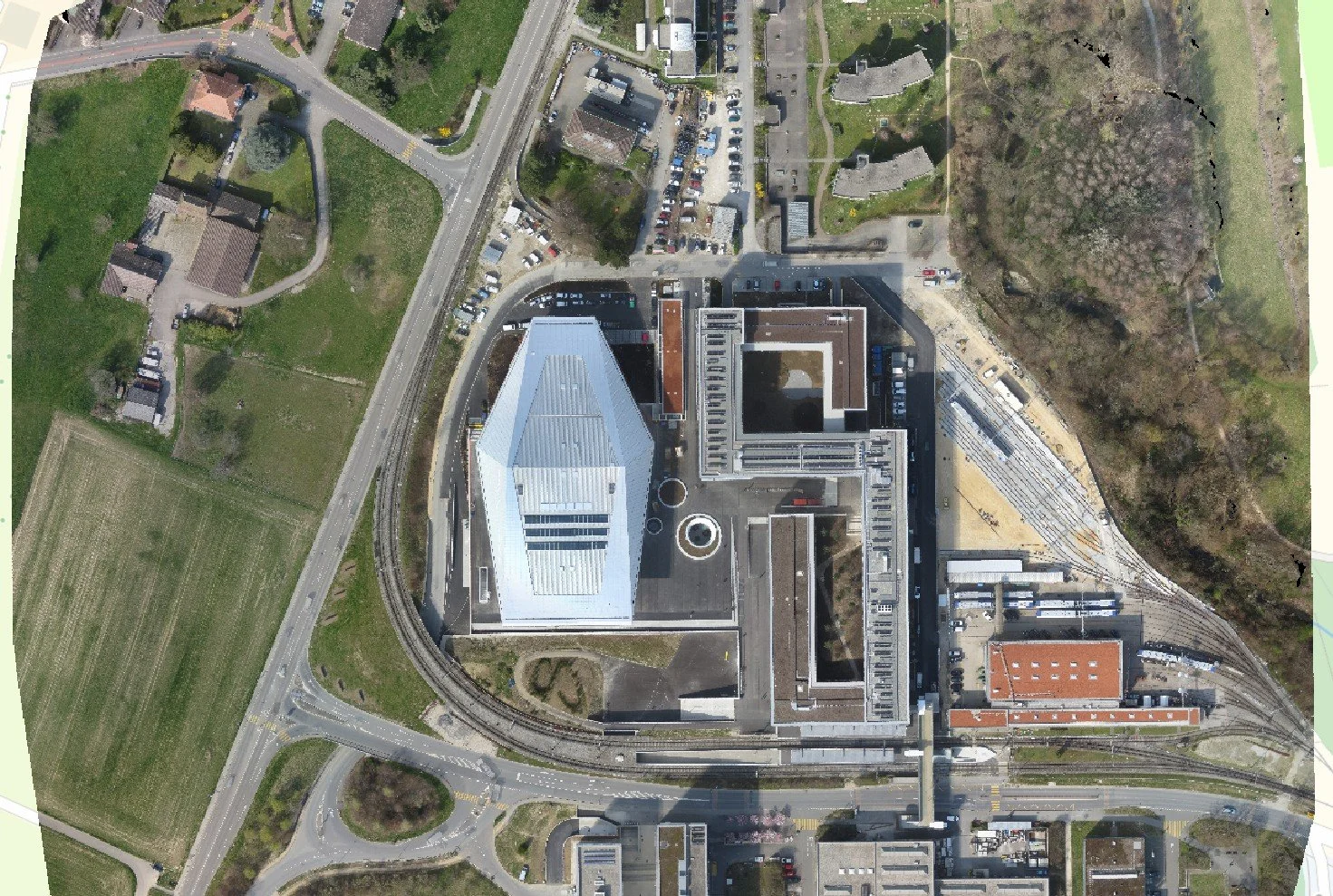
What an Orthomosaic Is
A distortion‑free, true‑to‑scale aerial map of your entire site. Droneology captures high‑resolution imagery and stitches it into a perfectly aligned, georeferenced map you can measure, annotate, and compare over time.
Why It Matters
Clarity, accuracy, and accountability in one deliverable. Use orthomosaics for progress tracking, as‑built documentation, site planning, compliance, and stakeholder reporting — all with measurable precision and full‑site visibility.
What Comes Next
Once you have a clear, distortion‑free map of the entire site, you can take the next step into full 3D intelligence. Droneology builds on your orthomosaic capture to generate high‑accuracy point clouds and photorealistic meshes — giving you measurable depth, geometry, and immersive 3D context for planning, verification, and stakeholder communication.
Meshes & 3D Models
When teams rely on outdated site photos, scattered measurements, or incomplete as‑builts, costly misunderstandings become inevitable. Critical details get missed. Approvals stall. Rework piles up. And everyone ends up making decisions without a clear, trustworthy picture of what’s actually happening on the ground. Construction decisions are only as good as the data behind them.
That’s where high‑resolution aerial point clouds and meshes change everything.
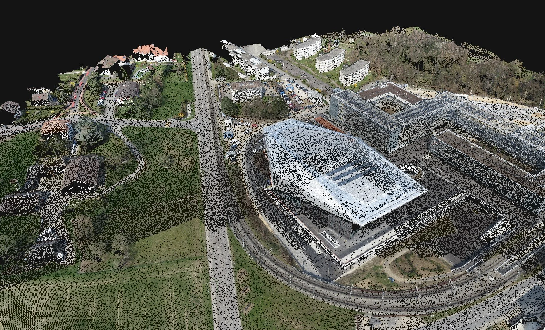
Point Clouds — Precision You Can Trust
Droneology captures millions of georeferenced points from above, producing a survey‑accurate digital twin of your site. You get:
Exact measurements you can verify, repeat, and defend
Full‑site visibility, including hard‑to‑reach or hazardous areas
Reliable as‑built documentation for coordination, RFIs, and progress validation
Point clouds give you the raw, measurable truth — no guesswork, no blind spots.
Meshes — Photorealism That Speaks for Itself
We transform that precision data into a smooth, textured 3D model that anyone can understand at a glance. You get:
Client‑friendly visuals that communicate instantly
Accurate geometry for planning, design reviews, and clash detection
Immersive context for stakeholders who need clarity, not complexity
Meshes turn complex site data into a visual experience that accelerates decisions.
The Combined Advantage
Together, point clouds and meshes deliver a complete, cinematic understanding of your project:
The accuracy of survey‑grade data
The clarity of photorealistic 3D models
The speed and efficiency of aerial capture
It’s the difference between hoping you have the right information — and knowing you do.