Orthomosaics & Survey-Grade Mapping

Orthomosaics
The Most Accurate View of Your Site, From the Sky Down
Orthomosaics turn tens, hundreds—or even thousands—of drone photos into a single, distortion‑free, measurement‑accurate map of your entire site. They give teams a level of clarity and precision that traditional ground photos, hand‑drawn markups, or stitched‑together screenshots simply can’t match.
Why Orthomosaics Matter
A single source of truth Every pixel is georeferenced, aligned, and corrected, giving you a reliable map you can measure, annotate, and compare over time.
Full‑site visibility in one glance Instead of piecing together progress from scattered images, you get a complete, top‑down view of the entire project—updated as often as you need.
Survey‑grade accuracy With proper ground control and flight planning, orthomosaics deliver the precision required for planning, documentation, and early‑stage decision‑making.
Track progress with confidence Overlay new orthomosaics against previous captures to see exactly what changed, what’s ahead of schedule, and where issues may be forming.
Better communication for every stakeholder Developers, contractors, inspectors, and owners all see the same accurate, up‑to‑date map—reducing confusion and accelerating approvals.
A permanent visual record Each orthomosaic becomes part of your project’s historical archive, supporting compliance, reporting, and dispute resolution.
What This Unlocks for Your Team
Smarter planning and coordination
Faster, clearer decision‑making
Reduced rework and fewer site visits
Stronger documentation for investors, clients, and regulators
A visual narrative that elevates your project and sets it apart
Survey-Grade Mapping with RTK & PPK
Precision you can build on
Survey‑grade mapping begins with one goal: capture the world exactly as it is, down to the centimeter. Droneology achieves this by combining RTK, PPK, and high‑resolution aerial imaging into a single, disciplined workflow that produces spatial data you can trust for planning, documentation, and decision‑making.
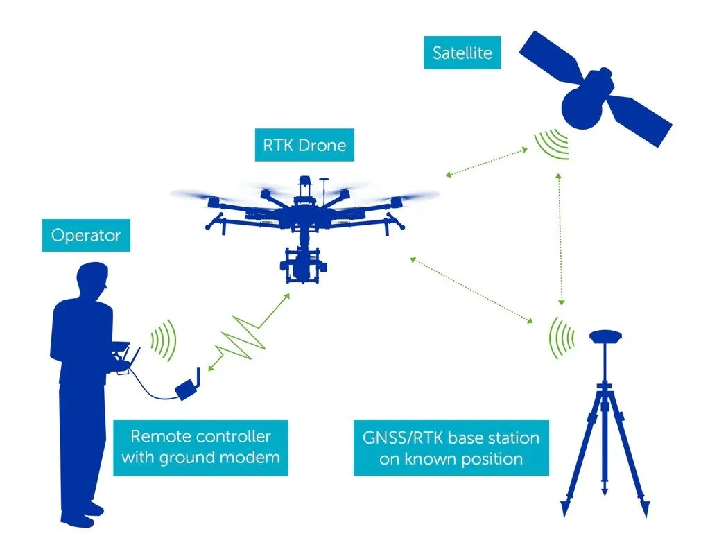
RTK (Real‑Time Kinematics) locks the drone into a corrected GPS position while it flies, ensuring every photo is taken from a precisely known point in space. This keeps flight lines tight, camera triggers consistent, and the entire mission aligned in real time. But real‑time signals can drop, drift, or degrade — especially around trees, buildings, or uneven terrain.
PPK (Post‑Processed Kinematics) closes that gap. After the flight, Droneology reprocesses the raw satellite logs against a stable reference station, correcting any momentary RTK interruptions and refining the trajectory with higher‑quality data. The result is a redundant, fail‑safe positioning system: RTK gives stability in the air, PPK gives accuracy on the ground.
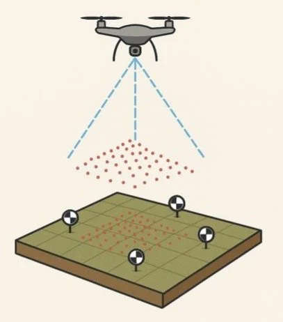
Layered on top of this is high‑resolution nadir and oblique imagery captured with disciplined overlap and consistent exposure. When processed through advanced photogrammetry, these images become a true‑to‑scale digital reconstruction of the site below — an orthomosaic, 3D model, or point cloud that reflects the real geometry of the environment.
Together, RTK + PPK + high‑resolution imaging produce maps that are:
Centimeter‑accurate
Geospatially aligned
Reliable for measurement and analysis
Defensible for construction, engineering, and documentation
This is more than aerial photography — it’s survey‑grade spatial truth, captured from above and refined with precision.
RTK
With normal GPS, devices know their location within a few feet because satellite signals have tiny timing errors. RTK (Real‑Time Kinematic) fixes those errors by using a nearby “reference point”, with a known exact position. Information from that point is broadcast in the form of correction data to a drone, rover, or receiver in real time, letting it adjust its GPS reading on the fly. The result is centimeter‑level accuracy, even while moving. In simple terms: RTK turns regular GPS from “somewhere around here” into “right here, down to the centimeter.” RTK gives you instant accuracy, but it’s vulnerable to real‑time conditions.
PPK
PPK — Post‑Processed Kinematic — is like giving your GPS data a second chance to get everything perfect. Instead of relying on live corrections like RTK, the drone records all its raw satellite data during the flight. Afterward, that data is matched against a known reference point on the ground — usually a ground control point (GCP) or a survey‑grade base station with precise coordinates. By comparing the drone’s raw data to that fixed, accurate point, PPK removes timing errors and drift to produce centimeter‑level accuracy even if the drone lost signal or flew in a challenging environment. In simple terms: PPK cleans up your GPS data after the flight using a trusted ground point, so your final map is as accurate as possible no matter what happened in the air.
RTK & PPK Together
Using RTK and PPK in tandem gives your project the highest level of positional accuracy possible — both in the air and after the flight. RTK delivers real‑time corrections that keep every photo, flight line, and camera trigger tightly aligned as the drone moves, while PPK reprocesses the raw satellite data afterward to correct any dropouts, interference, or signal gaps that occurred during the mission. Together, they create a redundant, fail‑safe positioning system that produces centimeter‑level precision even in challenging environments. The result is cleaner orthomosaics, tighter 3D models, more reliable measurements, and deliverables you can trust for construction, surveying, and documentation without second‑guessing the data.
What Comes Next
Once you have a clear, distortion‑free map of the entire site, you can take the next step into full 3D intelligence. Droneology builds on the images and metadata used withing your orthomosaic to generate high‑accuracy point clouds and photorealistic meshes — giving you measurable depth, geometry, and immersive 3D context for planning, verification, and stakeholder communication.